|
|
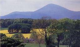
The Mourne Mountains.
'beanna boirch' |
|
Site Home Page | Find Businesses | History | Video | E Postcards | Famous People | Jigsaws Auto Services | Beauty | Bridal Salons | Building Services | Camp Sites | Car Boot Sales | Cruising Holidays | Creches | Diving Holidays | Engineering | Equestrian | Estate Agents | Events | Fairs & Shows | Family Services | Farmers Markets | Fishing || Florists | Fuels | Guest Houses | Hardware | Haulage | Hostels | Hotels | Insurance | Lingerie | Jewelers | Mens Wear | Museums | Music Sessions | Pet Services | Photographers | Self Catering | Taxi | Travel Agents | Vintage | Wedding Transport |
Mourne
Mountains |
|||||
A
|
|||||
|
|
The
Silent Valley. |
||
|
The Silent Valley is said to have derived its name from when construction of the dam began in 1904 the birds left the valley because of the disturbance. Most of the materials for the dam were brought to the site on a purpose built narrow gauge railway from the village of Annalong on the coast. A second dam Ben Crom was built in 1957 it is 230 yds (210M) across and 155 ft (42.25M) high. The catchment area of both dam's which amounts to an area of 9000 acres is enclosed by the Mourne Wall which was built between 1904-1922 is 22 miles long and approximately 8 feet (2.44 M) high it connects the summits of 15 mountains. Spare a thought for the men who built this wall, walking from their homes to the heart of the Mountains in all weather each morning and home again in the evening. The annual Mourne Wall Walk takes place in the summer and attracts walkers for far and wide. The water is carried to Belfast in a tunnel which passes through Slieve Binnian it then travels in pipes which generally follow the coast along the lower slopes of the mountains emerging near the village of Bryansford north of Newcastle. Work on this tunnel was begun at either end, when the two gangs met they were only inches out of alignment. More about The Silent Valley. |
||
Go
to Irish Mountains home page. |
|
|
Walks in the Mourne's.
|
||||||
|

