| |

|
County
Carlow from Samuel Lewis' Topographical
Directory of Ireland 1837
Carlow the name
comes from the Irish Ceatharlach (four lakes).It has
an area of 896 sq. Km (346 sq mi).
making it the second smallest county in Ireland, it
is situated in the Provence of Leinster, in the Southeast
of Ireland. Carlow's fertile soils make it ideal for
mixed agriculture. Arable crops are more important here
than in most other Irish counties, accounting for one
third of farm output. The crops are mainly cereals and
sugar beet. Most cattle are reared and fattened for
beef, but there is some dairying. Sheep farming is important,
especially in the upland areas of the east of the county.
Farms average about 30 hectares in area and are larger
than most other farms of Ireland. Farmers in the lowlands
of Carlow grow cereals, potatoes, sugar beet, and other
crops.
|
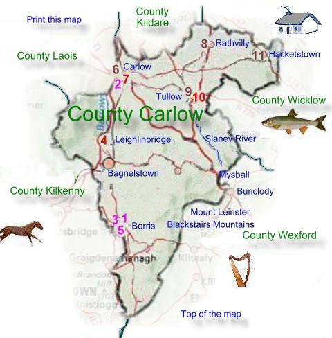
The river Barrow flows southward
through the county forming the western boundary with County Kilkenny
along part of its course, the valley of the Barrow has a limestone
floor. The lowland area in the Northeast sits on granite. The River
Slaney flows southeastward toward Wexford Harbour. Most of Carlow
is a flat with undulating lowland, the land rises to the east and
west. Along the eastern edge are the Blackstairs Mountains.
Carlow and Kilkenny jointly send five Td's
to Dail Eireann A county council based in Carlow administers the
county's local government.
Ireland's first sugar beet refining factory,
built in 1926, was a great boost to industrial development. Most
of the factories are modern. They produce tools, machinery, and
precision instruments. Other industries include meat processing
in Hacketstown and Bagenalstown, machinery in Bagenalstown and Borris,
and saw milling near Tullow. An important part of Carlow's manufacturing
industry is processing agricultural output and timber, and supplying
the needs of farmers. Half the manufacturing workforce is employed
in the metal and engineering industries and a further quarter in
food processing.
Carlow Town
Co Carlow
Tel +353 (0)599131554
E Mail
Web
Site |
Their highest peak is
Mount Leinster (795 meters). West of the Barrow, the land
rises to about 300 meters in the Castlecomer plateau, which
is formed of shale's and sandstone's.
Carlow is roughly triangular in shape.
Kilkenny is to the west and Wexford to the east, with Wicklow,
Kildare, and Laois to the north. |
|
|
|