| 
|
County
Clare from Samuel Lewis' Topographical
Directory of Ireland 1837
Clare is a county on the west coast, it's area
amounts to 3,188 sq. Km (1,231 sq mi)
is a county on the west coast, it's area
amounts to 3,188 sq. Km (1,231 sq mi)
The name comes from the Irish An Clar (the plain) It is situated
in the province of Munster
and is surrounded by the sea on three sides. It is bounded
on the west by the Atlantic Ocean, on the south by the Shannon
estuary, and to the north by Galway Bay.
The River Shannon and
Lough Derg separate it from Limerick and Tipperary in the
east. The county has become known as the banner county because
it has produced more than its fair share of politicians..
Clare is
very beautiful and attracts a large number of tourists. Its
major towns are Ennis, Shannon, Kilrush, Newmarket on Fergus
and Kilkee.
|
Clare sends four members of parliament to
Dail Erreann. The county is administered by a county council based
in Ennis. The town's of Ennis and Kilrush
have their own urban district councils.
In the east of Clare, the Slieve Aughty and
Slieve Bernagh mountains are formed of slate, shale, and sandstone.
These uplands rise to a height of 530 meter's.(1,736 Ft) Beneath
them lies the picturesque Lough
Derg on the River Shannon,
where pleasure boating is popular.
The major transport route is the national
primary N18 road northward from Limerick through Ennis to Galway.
The national secondary N67 serves the west of the county and is
joined to Ennis by the N68. The railway carries only freight traffic
and follows a route similar to the N18. The international Shannon
Airport is the country's second busiest airport and is mainly
for transatlantic traffic. It has the world's first duty-free shop.
Irish coffee was invented there. A car ferry crosses the Shannon
estuary from Killimer to Tarbert in Kerry.
The land rises to a low plateau
in west Clare. In the north lies the unique Burren area of barren
limestone landscapes. The Ailwee Caves are open to the public. There
is no surface water in the Burren. But the remainder of west Clare
has a damp landscape, with many rushes and peat bogs on top of shale's
and sandstone's. These rocks end on the west coast in the spectacular
Cliffs of Moher, which have a sheer drop of 200 metres (656 Ft.)
into the Atlantic Ocean. There are also beaches on this coast at
the resorts of Lahinch and Kilkee.
a low plateau
in west Clare. In the north lies the unique Burren area of barren
limestone landscapes. The Ailwee Caves are open to the public. There
is no surface water in the Burren. But the remainder of west Clare
has a damp landscape, with many rushes and peat bogs on top of shale's
and sandstone's. These rocks end on the west coast in the spectacular
Cliffs of Moher, which have a sheer drop of 200 metres (656 Ft.)
into the Atlantic Ocean. There are also beaches on this coast at
the resorts of Lahinch and Kilkee.
Ireland's largest power station
is at Moneypoint on the estuary of the River Shannon. It burns imported
coal. The country's first and largest river hydroelectric plant
uses the water of the Shannon at Ardnacrusha.
Video of The
Cliffs of Moher.
In the past its centre of power
was  n Tipperary
at the rock of Cashel, now a cluster of buildings on the crest of
an ancient mound. With a ruined Cathedral, round tower and the Romanesque
Cormac's chapel. The area around the lower Shannon appears to have
been populated from early times there are many prehistoric monuments.
The most notable of which are a cluster of sites around Lough Gur
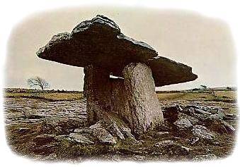
in Co Limerick and the Poulnabrone Dolman on the Burren
n Tipperary
at the rock of Cashel, now a cluster of buildings on the crest of
an ancient mound. With a ruined Cathedral, round tower and the Romanesque
Cormac's chapel. The area around the lower Shannon appears to have
been populated from early times there are many prehistoric monuments.
The most notable of which are a cluster of sites around Lough Gur
in Co Limerick and the Poulnabrone Dolman on the Burren
The Celts left behind them a
rich legacy of legend's of the pre Christian heroes. The hag Mal
is said to have attempted to follow the Ulster hero Cuchulainn in
making a giant leap at Loop or (Leap) Head, he fell into the sea
and his body was washed ashore at Mal bay.
Several abbeys were founded
in early Christian times, these  grew
and developed in medieval times under the protection of the Irish
chieftains. However the region is better known for the monasteries
which were founded in the 12th century by the austere and reforming
Cistercians, such as Monasterananagh in County Limerick, and Kilcooly
and Holycross in Tipperary.About 25 percent of Clare's people work
in agriculture. Farming is almost entirely pastoral with only about
one per cent of the land used for growing crops Farms are generally
larger than other western counties the average being about 20 hectares
in area. Cattle rearing and dairy farming
are the main activities. Milk is sent to creameries for processing
and most of the cattle are moved to farms in the east for fattening.
Farmers raise sheep in northern and upland areas, and some farmers
raise horses. There is forestry in the upland districts of eastern
and western Clare.
grew
and developed in medieval times under the protection of the Irish
chieftains. However the region is better known for the monasteries
which were founded in the 12th century by the austere and reforming
Cistercians, such as Monasterananagh in County Limerick, and Kilcooly
and Holycross in Tipperary.About 25 percent of Clare's people work
in agriculture. Farming is almost entirely pastoral with only about
one per cent of the land used for growing crops Farms are generally
larger than other western counties the average being about 20 hectares
in area. Cattle rearing and dairy farming
are the main activities. Milk is sent to creameries for processing
and most of the cattle are moved to farms in the east for fattening.
Farmers raise sheep in northern and upland areas, and some farmers
raise horses. There is forestry in the upland districts of eastern
and western Clare.
Read about County Clare from
Samuel Lewis' Topographical
Directory of Ireland published in 1837.
Tourist
Information
Aurthurs Row
off O'Connoll Square
Ennis
Co Clare
Tel +353 (0)65 6828366
Fax: +353 (0)65 6821234
E Mail
Web
Site |
The lowland
Centre of the county lies on limestone. There are many lakes
on its surface. Some of these are turloughs (lakes which dry
up in the summer). The River Fergus drains much of Clare and
runs into the Shannon estuary. |