| |

|
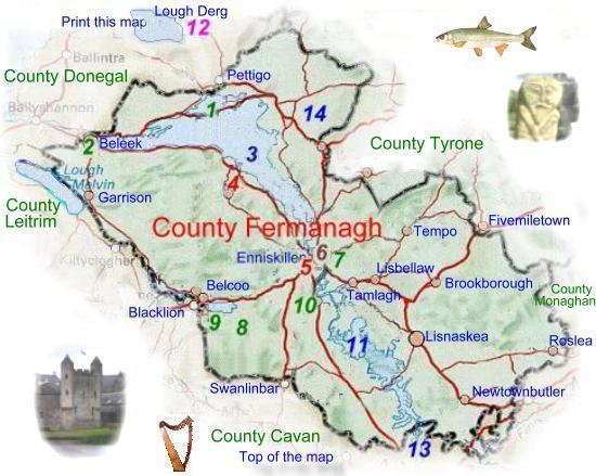
 County Fermanagh
from Samuel Lewis' Topographical
Directory of Ireland 1837 County Fermanagh
from Samuel Lewis' Topographical
Directory of Ireland 1837
Town's in County
Fermanagh from the Belfast and Ulster Towns Directory 1910.
With an area of 1849 sq Km (714 Sq M) Fermanagh
is one of the smallest counties in Ireland. The name comes from
the Irish Fir Manach 'men of tribe of Manach'. The county has many
lakes the largest Lough
Erne is linked to the Shannon-Erne
Waterway Canal, making the entire system the longest navigable
inland waterway in Europe.
|
The town would make an excellent base for a touring
holiday of Fermanagh, the National Trust properties of
Castle Coole, Florence Court, and Crom
Castle are all within a few miles of the town as well as the Marble
Arch Caves and the Sheelin
Lace Museum, all of the aforementioned are well worth a visit.
This together with its beautiful scenery make County
Fermanagh an ideal holiday destination for cruising
and other water based holidays, as well as equestrian
activities or just somewhere to escape the bustle of everyday life. Fermanagh
sends three members to the House of Commons, two for the county, and one
for Enniskillen.
Enniskillen situated between upper and lower Lough
Erne has long been a place of great military importance, the town and
surrounding area belonged to The Maguire clan. When the English finally
conquered the area in the early 1600's the town together with a large
tract of land was granted to Captain William Cole, a soldier in the army
of James I, It was descendants of Cole who built Florence
Court.
Tourist Information
Wellington Road
Enniskillen
Co Fermanagh
Tel +44 (0)28 6632 3110
E Mail
Web Site |
Read About Co
Fermanagh in 1837 from Samuel Lewis' Topographical Directory
of Ireland.
|
|
|