| |

|
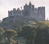
County
Limerick from Samuel Lewis' Topographical
Directory of Ireland 1837
from Samuel Lewis' Topographical
Directory of Ireland 1837
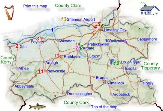
Limerick is located along
the the Shannon estuary and the river form much of its northern
boundary, County Tipperary is to the east, Cork to the south,
and Kerry to the west. It is one of the six counties in the
province of Munster, the name comes from the Irish Luimneach
which means barren land. Almost half of the population lives
in and around the city of Limerick which is the third largest
in the Irish Republic and the biggest in the western part
of the state.
Much of the remainder
of the county consists of pasture land and meadows. County
Limerick is roughly rectangular in shape, measuring about
80 kilometer's from east to west and 40 kilometer's from north
to south. Most of County Limerick consists of limestone lowland,
rising in places to hills of volcanic rock and sandstone.
The Rivers Deel, Maigue, and Mulkear (See
rivers) drain the lowland northward to the Shannon estuary.
|
| In
the northeast are the Slievefelim Mountains. In the west,
the land rises to a low plateau towards the Kerry border,
with the Mullaghareirk Mountains to the south. Some of these
upland areas have been planted with forest, these parts of
limerick are popular with hill walkers.
Limerick
City is the centre of the transport system, the city has a
railway connection to Limerick Junction in Tipperary, where
it meets the Dublin to Cork line. This line then passes through
the southeast of County Limerick. There is a branch line to
Nenagh and a freight only line to Foynes serving the port.
County Limerick receives most of the shipping on the west
coast of Ireland, the ports are the harbour of Limerick City
and the deep water ports of Foynes and Aughinish on the Shannon
estuary.
Limerick
City has many thriving Industries, almost half of industrial
employment is in light engineering. These includes electronic
engineering, household appliances and other electrical goods,
machinery and metal goods, also medical and optical supplies.
The proximity
of Shannon
airport which handles international flights, has considerably
benefited Tourism City and surrounding areas. The national
primary roads that radiate from the city within the county
are the N7 to Dublin, the N24 to Waterford, the N20 to Cork,
and the N21 to Tralee.
The upland areas
of County Limerick mostly all lie along its edges and are
shared with counties Clare and Tipperary.
They consist mainly
of sandstone's, shale's, and slates. The highest are the Galtee
Mountains,
which rise to 800 meters (2624 Ft) in the southeast. This
ridge continues westward as the Ballyhoura Mountains.
|
|
The computer industry
has in recent years become a major employer. Food processing, is also
an important contributor to the economy. It includes bacon and other meat
products, dairy processing, and milling. Other industry's produce building
materials, chemicals, clothing, furniture, wood products, and plastic
goods, as well as printing and publishing. There are two other major industrial
plants, one making cement near Limerick city and the other producing alumna
at Aughinish on the Shannon estuary. Limerick lace is one of the traditional
industries which still survives although on a much reduced scale.
The agricultural industry employs
about 17% of the workforce, most farms are of medium size, averaging about
25 hectares in size. The most fertile area of the county is often referred
to as 'The Golden Vale' it is situated in the center and east of the county,
the soils are best suited to grass and only 1 per cent of the land is
under arable crops. The rest used mostly for dairy and beef farming In
the west the land is less fertile some sheep are reared there.
Many people who
live commute to work on the Shannon industrial estate and airport in County
Clare. Service industries employ for over half the workforce. The city
is the major service centre for the Midwest region. These services include
catering, education, finance, health, public administration, retail and
wholesale distribution, and transport.
The University of
Limerick was formed in 1989 from the National Institute of Higher Education.
There are also third-level (higher education) colleges for art, business,
education, music, and technology.
Tourist Information
Arthur's Quay
Limerick
Co Limerick
Tel +353 (0)61 317522
Fax +353 (0)61 317939
E Mail
Web Site
|
The two parliamentary
constituencies together send eight representatives to Dail Eireann.
Local government is administered by a county borough corporation
for the city of Limerick and a county council for the rest of the
county.
Read about Limerick in 1837
from Samuel Lewis' Topographical Survey of Ireland.
|
|
|