 |
County
Meath.
|

|
| |
| County
Meath slideshow. |
|||||||
The River Boyne and its tributary
County Meath from Samuel Lewis' Topographical Directory of Ireland 1837 Beef cattle production is the leading type of farming. Cattle are imported from the south and west of Ireland and fattened on the fertile land of the county. Dairy farms supply milk to Dublin and to Irish creameries elsewhere. There are some stud farms for horse breeding. One eighth of the farmland is planted with arable crops, mainly barley, oats, potatoes, vegetables, and wheat. The county is administered by a county council which meets in Navan. Meath elects five members to Dail Eireann. English is the everyday language of almost all people. Although there are two small Gaeltacht, areas in which about half The three major roads from Dublin to Northern Ireland pass through Meath. The N4 road and the railway from Dublin to the west of Ireland pass along the southern boundary. The railway from Dublin to Belfast goes along the coast. A new motorway system was recently opened. Largest towns in the county are Navan the capital Trim, Kells, Laytown, Dunboyne and Duleek. One fifth of the people work in the manufacturing industry. Navan is the major industrial centre, with smaller industries in Trim, Kells, and Oldcastle. One of the world's largest lead and zinc mines is at Navan, it may still be in operation, I'm afraid I don't know. Meath enjoys a dry mild climate it is the driest place in Ireland with just 80 centimeter's along the coast and 100 centimeter's on the higher land to the north and west. The average temperatures are 5 °C in January and 15 °C in July.
|
|||||||
|
|

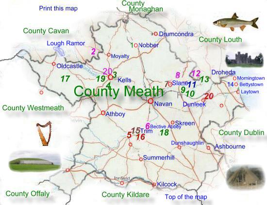
 is
bounded by seven counties and the Irish sea. It has Dublin
and the sea to the east, Kildare and Offaly to the south,
Westmeath to the west, and Cavan, Monaghan, and Louth to the
north. Meath is a mainly lowland which rises to hills of more
than 150 meter's along its northern borders. The county is
fertile with about 95 per cent of the land is agricultural,
on which about 20% of the population work.
is
bounded by seven counties and the Irish sea. It has Dublin
and the sea to the east, Kildare and Offaly to the south,
Westmeath to the west, and Cavan, Monaghan, and Louth to the
north. Meath is a mainly lowland which rises to hills of more
than 150 meter's along its northern borders. The county is
fertile with about 95 per cent of the land is agricultural,
on which about 20% of the population work.  the Blackwater drain much
of the county. The short and low coastline of Meath has several sandy
beaches, on one of these between the towns of Bettystown and Laytown a
horse race meeting is held each year, the date determined by the tides.
The county is drained by the River Boyne which joins the sea at Droheda,
and the river Nanny which meets the sea a little way south of Laytown.
the Blackwater drain much
of the county. The short and low coastline of Meath has several sandy
beaches, on one of these between the towns of Bettystown and Laytown a
horse race meeting is held each year, the date determined by the tides.
The county is drained by the River Boyne which joins the sea at Droheda,
and the river Nanny which meets the sea a little way south of Laytown.
|
|||||||
|
|
Google
Map of County Meath. |
||
|
|
||
|
|
|
|
|