| |

|
County
Roscommon from Samuel Lewis' Topographical
Directory of Ireland 1837
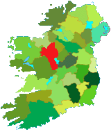
Roscommon is one of the five counties
in the Provence of Connacht. The name: comes
from the Irish Ros Comain (St. Coman's wood) after St Coman
who founded a monastery there in 746 AD. No trace of the monastery
has survived, it is believed that it once stood on the site
now occupied by the Anglican Church of St. Coman on Church
Street.
The county has a total area: 2,463
sq. Km. Together with its neighboring county Longford they
jointly elect four Td's to Dail Eireann Local government is
by a county council, based town. The major rivers in the county
are the Shannon and the Suck.
The annual rainfall is about 100 centimeters.
Average temperatures are 4 °C in January and 15 °C
in July. |
Tourist Information
Roscommon Town
Co Roscommon
Tel +353 (0)90 662 6342
E Mail
Web Site |
Summer only.
|
Much of Roscommon is underlain by limestone some of which especially
in the south is at or near the surface, this contributes draining
the land. In the north the soil is much deeper, and in places it
was formed into the small rounded hills called drumlins, these were
left behind by the receding ice sheets. There are peat bogs in poorly
drained areas throughout the county.
Roscommon is almost entirely a limestone
lowland. The limited areas of upland are in the extreme north. The
Curlew Mountains along the Sligo border are sandstone. The Arigna
area is part of a shale and sandstone plateau which is mainly in
Leitrim.
The county employs a greater number of people
in agriculture than any other county. Farming is mostly pastoral
only about two percent of the land being used for arable farming,
the crops grown are oats, barley and potatoes. The most fertile
area of the county and indeed Connacht is in the south and center
of the county. The most important farming activity is the rearing
of beef cattle. In the south sheep are also important.
Manufacturing industries employ only about
one quarter of the population. The main types are food processing,
engineering, and metal industries and are located at Ballaghaderreen,
Boyle, and Roscommon. |
Service industries account for two fifths of the
work force, with the retail sector leading the field. Other important
services include catering, community services, education, finance and
banking, and of course health care.
Roscommon has an exceptionally good road system,
with many arterial roads passing through the county. There are railways
from Athlone to Galway and Mayo, and through Boyle to Sligo.
Read about County Roscomon from Samuel Lewis' Topographical
Directory of Ireland published in 1837.
|
|

