| |

|
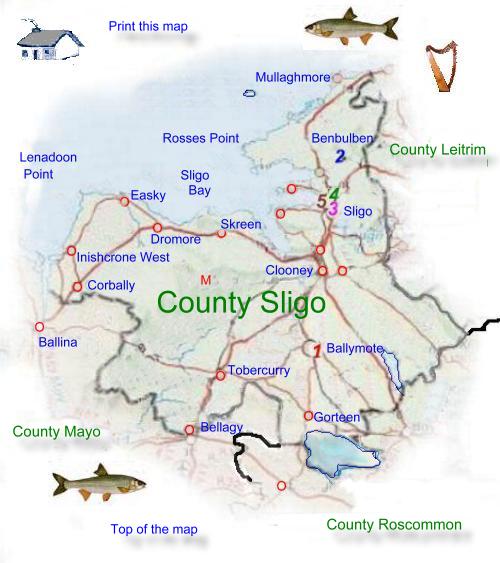
Sligo is one of the five counties
that make up the Provence of Connacht
it has a total land mass of 1,796 sq. km. (693 Sq. Miles) The Atlantic
Ocean forms Sligo's border to the north and northwest.
Counties Leitrim is to the northeast, Roscommon to the southeast
and Mayo to the southwest.
The largest towns are Sligo,
Tubbercurry, Ballymote and Collooney. The name Sligo comes from
the Gaelic Sligeach which means (Shelly place or river). Sligo together
with its neighboring county Leitrim elect four Td's to Dail Eireann.
The county council
is based town is in charge of local government administration.
Sligo has many mountains,
in the North a plateau extends across the border with Leitrim. Other
major mountains in the county are Ben Bulben, Knoocknarea, Curlew
Mountains and the Ox Mountains to the west.
The county
has many peat bogs both in the upland areas and also in poorly drained
lowland areas. The north and west coasts consist of coastal plains
with many fine sandy beaches.
|
The southern lowlands are drained by the river's
Moy and Owenmore. The annual rainfall is less than 120 centimeters on
the lowland, but much higher on the uplands. The average temperatures
are 5 °C in January and 15 °C in July.
southern lowlands are drained by the river's
Moy and Owenmore. The annual rainfall is less than 120 centimeters on
the lowland, but much higher on the uplands. The average temperatures
are 5 °C in January and 15 °C in July.
Over
fifty percent of the population work in the service industries, these
include education, health, and transport. Tourism is a substantial contributor
to the economy especially in the town's and coastal areas. About one sixth
of the population are employed in manufacturing, Sligo
town and Tubbercurry being the main Center's. main products include
the following in agriculture: cattle, milk, sheep, timber and in m anufacturing
building materials, clothing, engineering goods, food products, medical
supplies, timber products.
Sligo has good road and rail
connections with the rest if the Island, as well as a small port and
an airport. The county is known internationally in English literature
through the writings of William
Butler Yeats He spent much of his time, being inspired by its landscapes
and folklore. Northern Sligo is known as Yeats Country and hosts an annual
Yeats Summer School, Yeats is buried at Drumcliffe, beneath Ben Bulben.
Tourist Information
North West Tourism
Aras Reddan
Temple Street
Sligo
Tel +353 (0)71 9161201
Fax: +353 (0)71 9160360
E Mail
Web Site |
Farming was once an important
part of Sligo's economy employing about one fifth of the population,
farms are quite small averaging about 15 hectares (37 Acres) making
it difficult to make them an economic success. Like its neighbour
Leitrim the land is not suited to arable farming, beef and dairy
cattle are kept as well as sheep |
|
|