| |

|
County
Tipperary from Samuel Lewis' Topographical
Directory of Ireland 1837
Tipperary is one of the six counties of the province of Munster it has
an area of 4,254 sq. Km km (1,642 sq. mi). making it the largest
of the inland counties, it takes its name from the Irish Tiabraid
Arann 'the well of Ara'.
is one of the six counties of the province of Munster it has
an area of 4,254 sq. Km km (1,642 sq. mi). making it the largest
of the inland counties, it takes its name from the Irish Tiabraid
Arann 'the well of Ara'.
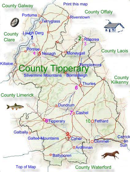
Its largest towns are
Clonmel, Thurles, Nenagh, Carrick-on-Suir, Tipperary, Roscrea,
Cashel, Templemore, Cahir and Fethard. Tipperary has borders
with Laois and Kilkenny to the east, Waterford and Cork to
the south, Limerick and Clare to the west, Galway and Offaly
to the north. The greatest distances are 105 kilometer's from
north to south and 70 kilometer's from east to west. |
Most of the lowland of Tipperary
consist of limestone covered by glacial deposits and peat bogs.
The upland areas are generally sandstone shale and slate. In the
south the Galtee Mountains rising to 920 metres (3017 Ft) also the
Knockmealdown Mountains and Slievenamon. In the east are the Slieveardagh
Hills, and to the west is the extensive Silvermine Mountain system.
This extends northeastward to Devilsbit Mountain and the Arra Mountains
overlooking Lough Derg.
The River Suir drains much of
the land southwards. Northern and western parts of the county drain
towards the River Shannon and Lough Derg, which forms the northwestern
boundary. This is a very popular area for pleasure boating, with
several cruiser hire companies
operating in the area.
Service industries employ about
50% of Tipperary's workforce, about 20% are employed in manufacturing.
There is some mining in the north. The leading service industry
in the whole county is the retail trade. There is a peat briquette
factory near Thurles. Coal is mined at Ballingarry, and barytes,
a mineral formed from barium sulphate is also mined. (These mines
may not still be in production, perhaps someone can tell us.) There
are some forests on the upland areas.
The Garda Siochana main training
centre is at Templemore. Food processing is of major importance's
manufacturing industries. Meat, milk, and milling industries developed
out of the county's farming activities.
Modern engineering industries
include the manufacture of electronic and electrical goods, and
fabricated metal products. Clonmel is the largest manufacturing
centre, with products that include cider, computers, dairy products,
fibreboard, leather, meat, pharmaceuticals, printing, radiators,
soft drinks, and textiles. |
The agricultural land is generally
fertile, except in the upland districts. Farms average about 27 hectares.
In the south west dairying is the main farming activity, farmers in other
areas rear and fatten beef cattle. The uplands are used  mostly
for Sheep grazing, a few farms are engaged in horse breeding while in
the south there are quite a lot of pig farms. About 15% of the land is
used to grow arable crops these include sugar beet and potatoes being
the main root crops, barley is grown for animal feeding and malting, wheat
is also grown. The number of people emploted in agriculture has declined
steadily during the past decade. mostly
for Sheep grazing, a few farms are engaged in horse breeding while in
the south there are quite a lot of pig farms. About 15% of the land is
used to grow arable crops these include sugar beet and potatoes being
the main root crops, barley is grown for animal feeding and malting, wheat
is also grown. The number of people emploted in agriculture has declined
steadily during the past decade.
The major roads and the railways are those linking
Dublin with Cork and Limerick, and Limerick with Waterford. The national
primary roads are the N7 through Nenagh to Limerick, the N6 through Cashel
to Cork and the N24 through Tipperary and Carrick-on-Suir. Limerick Junction,
which is near Tipperary town, is Ireland's second most important railway
junction after Dublin. The lines are to Dublin, Cork, Limerick, and Waterford.
A branch railway from Limerick to Ballybrophy serves Nenagh and Roscrea.
|
|