| |

|
County
Tyrone from Samuel Lewis' Topographical
Directory of Ireland 1837
The Moy from Slater's
Commercial Directory 1846.
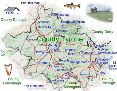
Tyrone is an inland county
in the Provence of Ulster Northern Ireland, it takes name
from the Irish Tir Eoghain, which means the land of Eoghain.
With an area of 3,263 square kilometer's (1,259 Sq miles)
it is the largest county in Ulster, it is bounded by County
Londonderry
to the north, Lough Neagh to the east, County Armagh to the
southeast, and the border with County Donegal to the west
and County Fermanagh to the south.
The central
part of County Tyrone is mainly flat, low-lying bog and moorland
these areas are infertile and are used mainly for sheep grazing.
In the north, the the highest mountain in the Sperrin
range rises to 683 metres (2249 ft) . The valleys of Tyrone
are fertile and are drained by the Blackwater and Ballinderry
rivers,
which flow eastward into Lough Neagh. In the west, the Glenelly,
Owenkillew, and Strule rivers combine with the Mourne which
flows through the town of Strabane and thence into the Foyle
above its wide estuary. |
The  Clogher
Valley in south Tyrone is extremely fertile and crosses the best
woodland and agricultural land in the county. In the south, the
local rock consists mostly of sandstone and limestone. Clogher
Valley in south Tyrone is extremely fertile and crosses the best
woodland and agricultural land in the county. In the south, the
local rock consists mostly of sandstone and limestone.
The town of Coalisland which was originally
called Brackaville, takes its name from the coalfields which are
no longer worked, the opening of these workings in 1723 by one Francis
Seymour, were the instigation of the building of the Newry
Canal, built to take the coal to Dublin, this was the first
canal to be built in Ireland and indeed in the British Isles. Clay
is excavated in the area and used in the local brick making industry.
Tyrone is mainly a farming county, it has hundreds of small farms
which mainly produce cattle and dairy produce. They also grow oats,
barley and potatoes.
The major towns of Tyrone are Omagh,
Dungannon, Cookstown
and Coalisland. Omagh has a fine courthouse and is the hub for routes
passing through the middle of Northern Ireland. Dungannon and Cookstown
are situated in the Lough Neagh lowlands. Dungannon was once the
major centre for the linen industry in the county which brought
significant prosperity to the area.
Clogher
is a small cathedral town, the seat of both a Church of Ireland
and a Roman Catholic bishop. Other small towns are Stewartstown,
Fintona, Strabane, and Aughnacloy.
For the angler there is excellent fishing
in the rivers. |
Read about County Tyrone from Samuel Lewis' Topographical
Directory of Ireland 1837
|
|