| County
Kildare from Samuel Lewis' Topographical
Directory of Ireland 1837
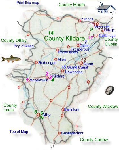
Kildare is bounded on
the north by Meath, on the east by Dublin and Wicklow, on
the south by Carlow, on the southeast by Laois, and on the
northeast by Offaly. Kildare has a land area of 1,694 sq km
(654 sq mi) The land of Kildare is largely rich farm land,
with the exception of the Northwest in which lies the Bog
of Allen. is bounded on
the north by Meath, on the east by Dublin and Wicklow, on
the south by Carlow, on the southeast by Laois, and on the
northeast by Offaly. Kildare has a land area of 1,694 sq km
(654 sq mi) The land of Kildare is largely rich farm land,
with the exception of the Northwest in which lies the Bog
of Allen.
The county is traversed
by the Grand
and Royal canals
connecting Dublin to the west, rivers in the county are the
Barrow, Boyne, and Liffey. Much of the county is underlain
by carboniferous limestone.
To the south of the county
there is an area of approximately 2,400 hectares (6,000 acres)
known as the Curragh This area is world-famous for horse breeding
and racing, and is a major source of employment, and revenue.
|