 |
Welcome to Google map of County Mayo |
|
| |
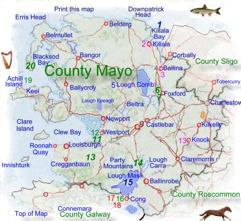
TheThe The town of Knock in east Mayo attracts pilgrims from across Europe and indeed the world, to the church where in 1879 children claimed the Virgin Mary appeared to them. On the last Sunday in July people from across Ireland assemble for a pilgrimage up Croagh Patrick, a mountain where St Patrick spent time in meditation and prayer. Tourism is an important part of the Mayo economy, especially in the mountainous and coastal areas. The land of Mayo is poor and largely unsuitable for arable use, most of the land is used for grazing with beef cattle, dairy farming and sheep, farms in the area tend to be small making it difficult for them to be efficient. About 30% of the people work in agriculture. re are some manufacturing industries mainly in Ballina and Castlebar, producing clothing and textiles, with a few company's producing light engineering goods. About 16% of the population work in these industries. There is a large synthetic textile factory at Killala. The service sector account for over 40% of employment, particularly retail and wholesale distribution. Other service industries include catering, education, health, and transport. Some of the upland areas are given over to forestry. Fishing is important in the coastal areas. Some of the county's power requirement is met by a peat powered station at Bellacorick in the northwest. Mayo has two constituencies and sends six Td's to Dail Eireann. The administrative center of the county is at Castlebar. The county has a good road system with the N5 from Castlebar toward Dublin and the N17 between Sligo and Mayo. A railway from Dublin through Claremorris branches to serve both Westport and Ballina. Horan International Airport, near Knock, opened in 1986.
|
|||||||
|
|


Google
Map of County Mayo. |
|||||||
|
|||||||
|
|
Google Map of
County Mayo. |
||
|
|
||
|
|
|
|
|