 |
Welcome to Google map of County Wicklow |
|

| |
| Collection
of video's about County
Wicklow by Martin Blake. |
||||
In the north of the county there is quarrying of stone, sand and gravel for building materials. Peat cutting for domestic fuel takes place on the mountains The greatest distances are 60 kilometers from north to south, and 50 kilometers from east to west. Arklow is the only fishing port. The Wicklow
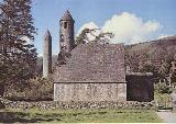
Mountains The mountains are utilized for the supply of water and hydroelectric power, mainly to Dublin City. Blessington Reservoir in west Wicklow, is the main source of Dublin's water. At its southern end is the Poulaphuca power station. There is a smaller reservoir at Roundwood in east Wicklow. In the mountains at Turlough Hill there is a large pumped storage electricity plant. The mountains attract a large number of people, for sightseeing, driving, cycling, and walking. On the eastern side of the mountains are a series of deep glens and valleys The most famous of these is Glendalough, with its two lakes. At Powerscourt there are waterfalls and gorges, also at the wooded Glen of the Downs. The eastern slopes drain mainly to the River Avoca through the Vales of Clara and Avoca, and the Meeting of the Waters made famous by the song of Thomas Moore. The valleys on the western flanks of the mountains are more open, as in the Glen of Imaal. The west of the county is drained mainly by the Rivers Liffey and Slaney. Service industries are the major employer in the county accounting for three fifths of employment. Tourism and recreation are of major importance. Only about one eighth of Wicklow workers have jobs in agriculture. Farming in the uplands is quite different from that on the lowlands. The amount of good land on farms is limited, and there is little arable farming. Sheep, which graze on the mountains, are very important. There is also rearing of young cattle. The lowlands are fertile and have more mixed farming. Barley, wheat, and potatoes are the main crops, with some oats, sugar beet and turnips. Beef cattle production is of major importance. There is dairy farming supplying milk to Dublin. The major transport routes in Wicklow sends five members to Dail Eireann. Local government is carried out mainly by a county council based town. There are urban district councils in Arklow, Bray, and Wicklow. The annual rainfall rises from less than 100 centimeters along the coast to over 200 centimeters on the higher mountains. The average temperatures are 5 °C in January and 16 °C in July. During the 1970's there was a short-lived upsurge in the traditional copper-mining industry in the Avoca valley. |
||||
|
|


 situated
in the centre of the county and dominate its landscape. They are the major
part of the Leinster Chain, which is the most extensive area of upland
in Ireland. The mountains are mainly granite, which is formed into smoothly
rounded peaks. Lugnaquilla 926 meters (3037 Ft) is Leinster's highest
mountain. The sharp peak of Great Sugar Loaf mountain is a prominent feature
in the Northeast of the county.
situated
in the centre of the county and dominate its landscape. They are the major
part of the Leinster Chain, which is the most extensive area of upland
in Ireland. The mountains are mainly granite, which is formed into smoothly
rounded peaks. Lugnaquilla 926 meters (3037 Ft) is Leinster's highest
mountain. The sharp peak of Great Sugar Loaf mountain is a prominent feature
in the Northeast of the county.
 Wicklow
are the railway and N11 road along the eastern lowland from Dublin
to Wexford. Arklow is a small port, boat building was carried on
there by Tyrell's who built many fine fishing trawlers, yachts and
pleasure craft, I really don't know if they are still in business,
hopefully they are.
Wicklow
are the railway and N11 road along the eastern lowland from Dublin
to Wexford. Arklow is a small port, boat building was carried on
there by Tyrell's who built many fine fishing trawlers, yachts and
pleasure craft, I really don't know if they are still in business,
hopefully they are.
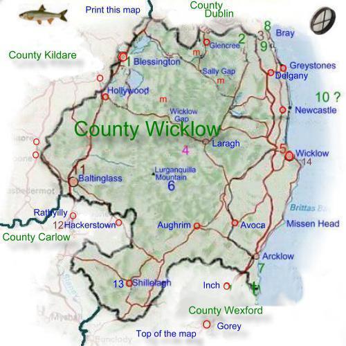
Map
of County Wicklow. |
|||||||
|
|||||||
|
|
Google
Map of County Wicklow. |
||
|
|
||
|
|
| |
|