| |

|
County
Leitrim from Samuel Lewis' Topographical
Directory of Ireland 1837
 Leitrim's beauty
is extolled in the song Lovely Leitrim. The
name is derived from the Irish Liath-druim (grey ridge) Leitrim
is the most used place name in Ireland. Leitrim's beauty
is extolled in the song Lovely Leitrim. The
name is derived from the Irish Liath-druim (grey ridge) Leitrim
is the most used place name in Ireland.
The North of the county is mountainous, the
south has many picturesque lakes. It is long and narrow being
eighty kilometers from Northwest to Southeast, and has an
area: of 1,525 sq. km (568 Sq miles)
The annual rainfall is
100 centimeters on the lowlands and over 150 centimeters on
the uplands. The average temperature in January is 5 °C.
And July 15 °C. The population now is approximately one
quarter of what it was in 1850. The largest town is Carrick-on-Shannon.
Four members of parliament represent Leitrim and Sligo in
Dail Eireann. It is one of the five counties that make up
the province of Connacht. |
It shares its border
with six other counties Fermanagh in Northern Ireland. County Donegal
to the north, County Cavan to the northeast, County Longford to
the southeast, County Roscommon to the southwest, and County Sligo
to the west. border
with six other counties Fermanagh in Northern Ireland. County Donegal
to the north, County Cavan to the northeast, County Longford to
the southeast, County Roscommon to the southwest, and County Sligo
to the west.
Leitrim's land
is for the most part wet and infertile, only about one percent of
the land is suitable for cultivation, the remainder is grassland
which is used for rearing beef cattle and for dairy and sheep farming.
About thirty percent of Leitrim's population work in agriculture.
There is a well worn joke  saying
that 'Leitrim is sold by the gallon not by the acre'. saying
that 'Leitrim is sold by the gallon not by the acre'.
There are some manufacturing industry in
the county, they consist of clothing, electrical and other metal
goods, food and timber products. About one sixth of Leitrim's population
work in these industries, which are located mainly in Manorhamilton,
Mohill, Ballinamore and Carrick-on-Shannon.
Southern Leitrim's bedrock which is mainly
limestone is covered with drumlins (small egg shaped hills) formed
from material left behind by the glaciers of the last ice age. Northern
Leitrim consists of a high plateau, cut by deep valleys. Lough Allen
the largest lake and the source of the Shannon pictured above lies
in the broad central valley. |
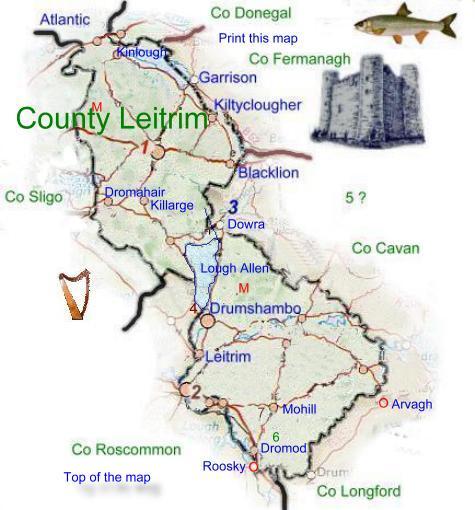
Leitrim is almost entirely landlocked save for
a coastal strip 3.22 Km (2 Miles) long between the county boundaries of
Sligo and Donegal.See county map.The county has many
beautiful lakes, the chief of which are Lough Garadice, Lough Gill, Lough
MacNean, Lough Allen, Lough Glenade, Lough Rynn, and Lough Melvin, the
latter shares its eastern shore with County Fermanagh. All the lakes are
exceptionally picturesque and afford excellent opportunities for all types
of fishing.
Tourist Information
Carrick on Shannon
Co Leitrim
Tel +353 (0)71 9620170
Fax +353 (0)71 9620089
E Mail
Web Site |
Seasonal Tourist information
only.
Read about Co
Leitrim in 1837
|
|
|